
Individual projects that advance the big ideas can significantly impact campus systems but also present opportunities for coordination and optimization consistent with well-established planning principles. The Three Zeros Environmental Initiative and decades of planning have established the importance of investing in the campus landscape and pedestrian environment, understanding that landscapes, utilities and buildings must work together, promoting alternate modes of transportation to manage congestion and parking needs, and maintaining a commitment to an integrated approach to infrastructure planning.

Campus Systems Map
Open space is a central organizing element of campus that connects people to place. It is an essential part of the Carolina brand and supports a variety of academic and residential life activities. Open spaces can also provide valuable ecological functions such as stormwater management, animal habitat, food production, and clean air. Maintaining a diverse, connected network of passive unprogrammed spaces, active programmed spaces, and natural preservation areas is a core strategic component of the plan. A highly connected open space network requires coordination with environmental management efforts, transportation infrastructure, utility infrastructure, and service infrastructure.

The Master Plan proposes a variety of campus landscape types and scales that will contribute to a rich and cohesive open space network. Each building project should be seen as an opportunity to make landscape and campus systems investments to create a more connected and cohesive campus environment. Wayfinding will be addressed holistically for the entire campus as well as at the individual project level. New transformative open spaces, such as the Campus South Hub, will feature a variety of formalized landscapes that interface with larger existing and proposed natural areas. Mature open spaces in Campus North will continue to be refined with small, intentional initiatives such as screening of service areas, adjustments to pathways, and the addition of landscape features to strengthen the character of the area. The Master Plan continues to improve the landscape character of roadways throughout campus; for example, Stadium Drive is treated as both an open space corridor as well as a multimodal path of travel.
The University has a long history of utilizing management strategies that embody environmental awareness and stewardship. Recently developed environmental strategies that inform the Master Plan include the 2016 Three Zeros Environmental Initiative, which charges future University actions with creating a Carolina that contributes to the resilience, restoration, and sustainability of natural resources. These are comprehensive, challenging tasks that the master planning process has striven at every turn to incorporate.
  • Ensure that every project contributes to enhancing open space networks, environmental management, and sustainability initiatives.
  • Continue to comply with all environmental regulations.
  • Balance capacity and programmatic needs with potential open space opportunities.
  • Minimize the impacts of campus development on natural resources such as the campus tree canopy and waterways.
  • Work with existing topography and natural features.
  • Integrate research, teaching, and practice with campus environmental and resource issues.
  • Continue to develop student, faculty, and staff stewardship of the campus through initiatives such as the Carolina Campus Community Garden, Edible Campus, and the Botanical Garden volunteer program.
Effective transportation strategies allow the University to address limited capacity on the main campus, fully realize the capacity of redevelopment sites, and address the multimodal transportation needs of a growing community. Investments should prioritize open space and the pedestrian environment and promote alternate modes including transit and bike. Transportation planning must continue to take into consideration local, community, and regional connections and develop policies for emerging forms of travel such as electric scooters and driverless vehicles.

The Master Plan builds on a comprehensive pedestrian network. It identifies a series of key pedestrian corridors with the goal of connecting the entirety of the campus along high-quality paths. This includes paths along the western edge of the campus parallel to Columbia Street and through the core from the Kenan-Flagler Business School to Craige Residence Hall to Rams Head Plaza and beyond. These will be complemented by several key improvements, including enhancements to Paul Hardin Drive, Stadium Drive, and pedestrian bridges across South Road.

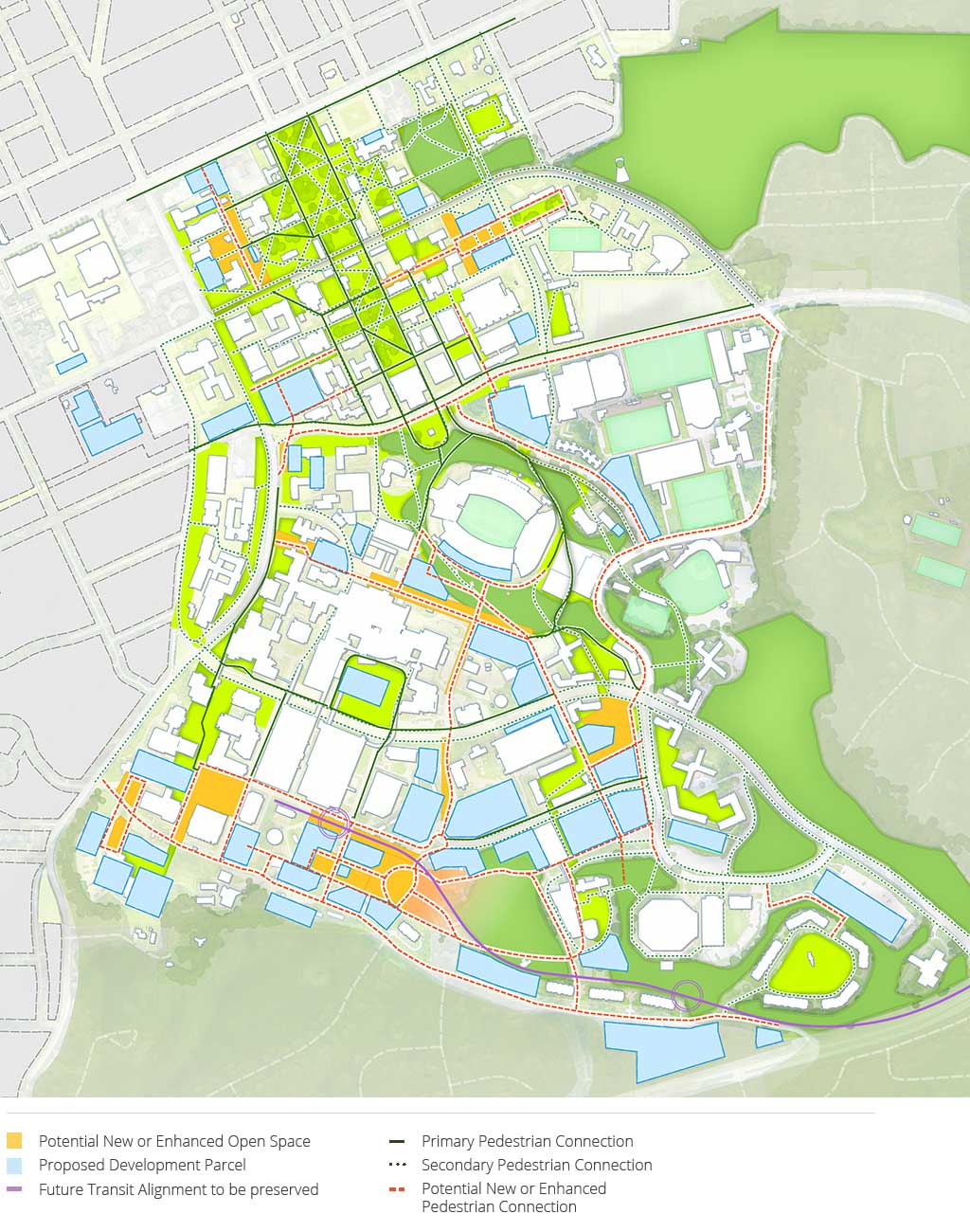
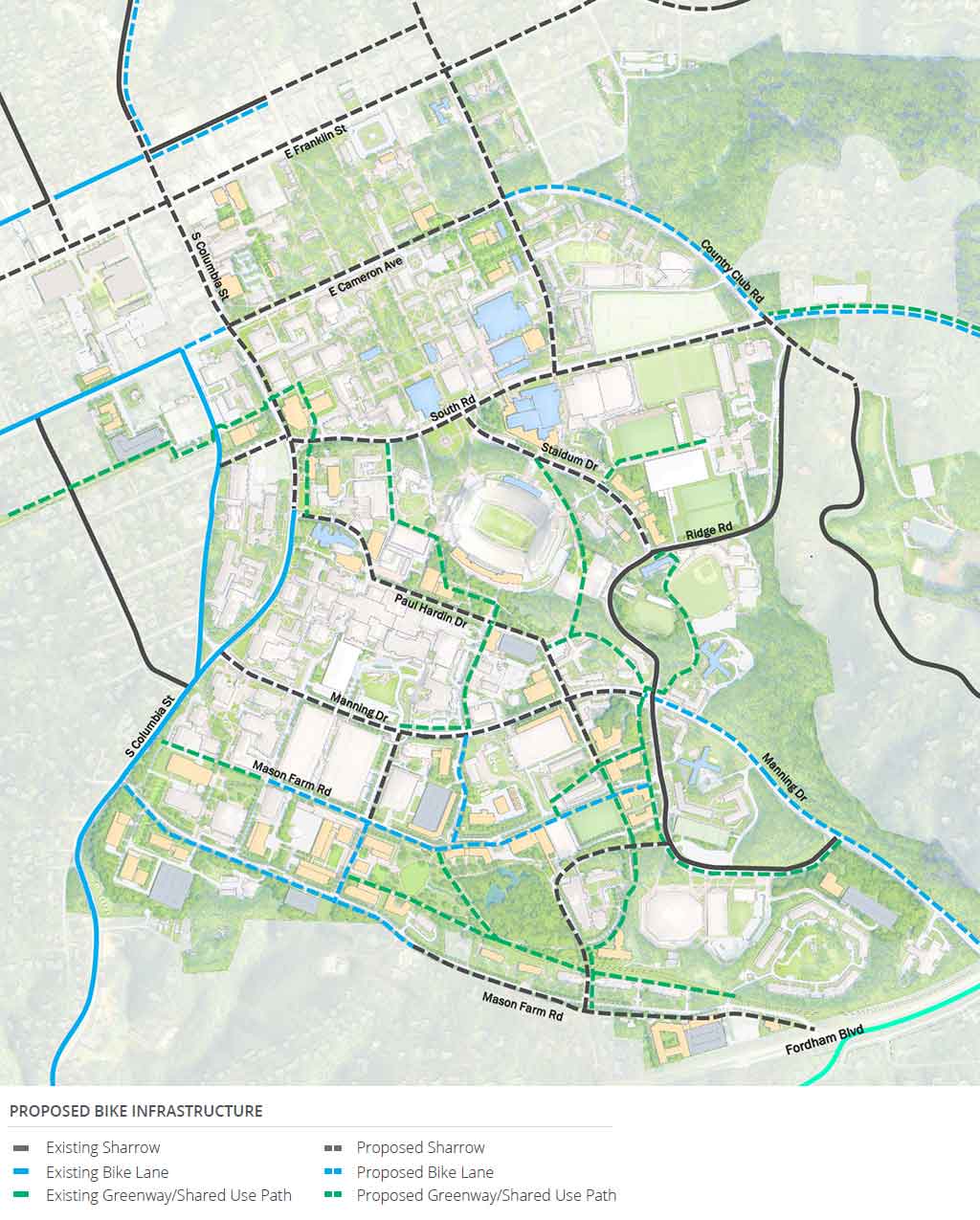
In the short term, the Porthole Alley plan will enhance connections between the University and Franklin Street. Over time, the transformation of Campus South will improve the pedestrian environment through the creation of an urban street grid and the implementation of plazas, open space, and enhanced streetscape.

Road Sections

The vision for future campus streets embraces and enhances the existing network. Recognizing that vehicle capacity on adjacent roadways is limited, the Master Plan identifies a series of street realignments to allow better circulation and access in Campus South as that area is transformed in years to come. Potential improvements include:

  • Realignment and extension of William Blythe Drive to East Drive through present-day Odum Village, which is slated for demolition.
  • Realignment of Mason Farm Road to run parallel to William Blythe Drive and connect with West Drive at the southwest corner of the proposed Translational Research Building. In the long term, the new Mason Farm Road alignment could be extended to South Columbia Street.
  • East Drive could be extended south from the Jackson Parking Deck to meet the realigned Mason Farm Road.
  • Over time, in conjunction with improvements planned by the Town of Chapel Hill and the NCDOT, Oteys Road could be widened to allow a turn lane and better connection with the proposed signal along Fordham Boulevard.

Proposed Street Network

The Master Plan reinforces the vision for the bicycle network laid out by the Bicycle Master Plans for the University and for the Town of Chapel Hill. The plan will develop a comprehensive system of on- and off-road bicycle facilities which will allow easy and safe navigation of the campus by bicycle. These will connect to improved facilities within the Town offering easy connections to surrounding neighborhoods as well as further destinations, including Carolina North and Mason Farm. The plan recognizes that some streets may be best served with shared streets, encouraging slow speeds and mixed flows by all users.

Proposed Bike Infrastructure

The Town of Chapel Hill and the Town of Carrboro, supported by the University, have embarked on plans to introduce high-capacity transit to the Town and campus. Bus Rapid Transit (BRT) is planned to connect the Southern Village Park and Ride via South Columbia Street and Martin Luther King Jr. Boulevard to the Eubanks Park and Ride near I-40. The service would provide a direct connection to Carolina North and currently plans to enter campus via Mason Farm Road and Manning Drive with additional stops near South Road and Cameron Avenue.

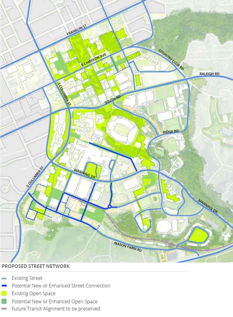
Following the recent discontinuation of light rail planning in Orange and Durham counties, the University continues to identify opportunities for a regional transit hub in Campus South and will maintain a corridor for a future transit alignment. Future transit stops along NC 54 could provide enhanced access and connections between Campus South and Mason Farm.

The Master Plan attempts to strike a balance between limited development capacity on the main campus and parking demand. For many, travel via car is the only option to reach campus. At the same time, the plan recognizes that the addition of vehicles to the campus is at odds with the goal of an improved pedestrian experience, sustainability objectives, and redevelopment. For the historic core in Campus North, the 15-year plan emphasizes maintaining existing parking supply. The long-term plan identifies opportunities to provide additional parking capacity in combination with other connectivity enhancements.

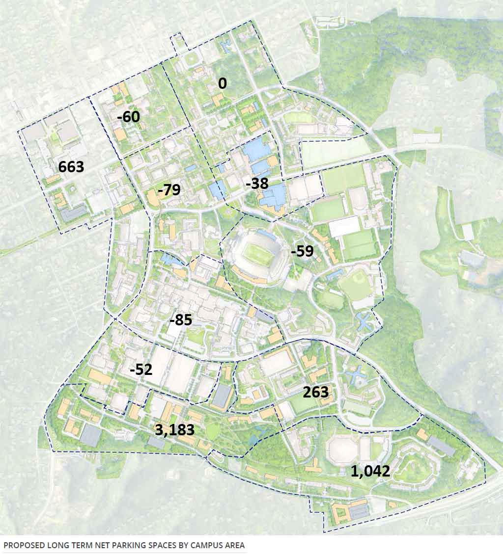
Most of the growth on campus will occur in Campus South, with the development of the Campus South Hub. The parking strategy reflects this with the planned addition of multiple parking garages in this area of campus. The Master Plan recognizes that for the innovation partnerships to be successful and attract tenants, parking may need to be provided at more suburban levels, at least initially. The plan provides long-term flexibility, offering additional locations for new parking facilities should they be needed. The vision, however, includes increased use of transit, and other non-auto modes reducing the long-term parking demand on campus.

Proposed Long-Term Net Parking Spaces by Campus Area

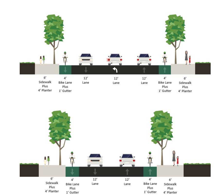
  • Utilize transportation infrastructure enhancements to fully realize the capacity of campus redevelopment sites.
  • Coordinate building and open space projects to realize long-term connectivity improvements identified in the Master Plan.
  • Ensure a welcoming experience for visitors by leveraging multimodal transportation systems, improved wayfinding, and parking resources.
  • Work with the Town of Chapel Hill and other partners to coordinate city and regional transportation opportunities.
  • Identify and implement opportunities for new parking resources that support proposed redevelopment in areas such as Campus South.
  • Embed flexibility in transportation infrastructure to respond to emerging technologies.
Infrastructure decisions impact reliability, environmental footprint, and development costs. The planning and design processes will continue to identify strategies to locate buildings where conflicts with major utility corridors are minimized, plan for future utility distribution, reduce energy and water use intensity, and continue to incorporate stormwater management techniques into every project involving campus landscapes.

The Master Plan encourages continued collaboration with facilities management and utility infrastructure. In addition to lowering costs and risk by carefully siting new buildings away from utility infrastructure conflicts, continual coordination can minimize the construction of additional utility infrastructure and optimize efficiencies. The plan has identified utility impacts for each parcel under consideration for development.
To fulfill regulatory requirements and sustainability goals, the University incorporates stormwater control measures into all campus construction projects. As part of the previous Stormwater Master Plan, projects to improve water quality and reduce flooding were identified.
  • Locate buildings to minimize conflicts with major utility corridors.
  • Plan for new and expanded energy systems based on the principles of reliability and life-cycle cost efficiency.
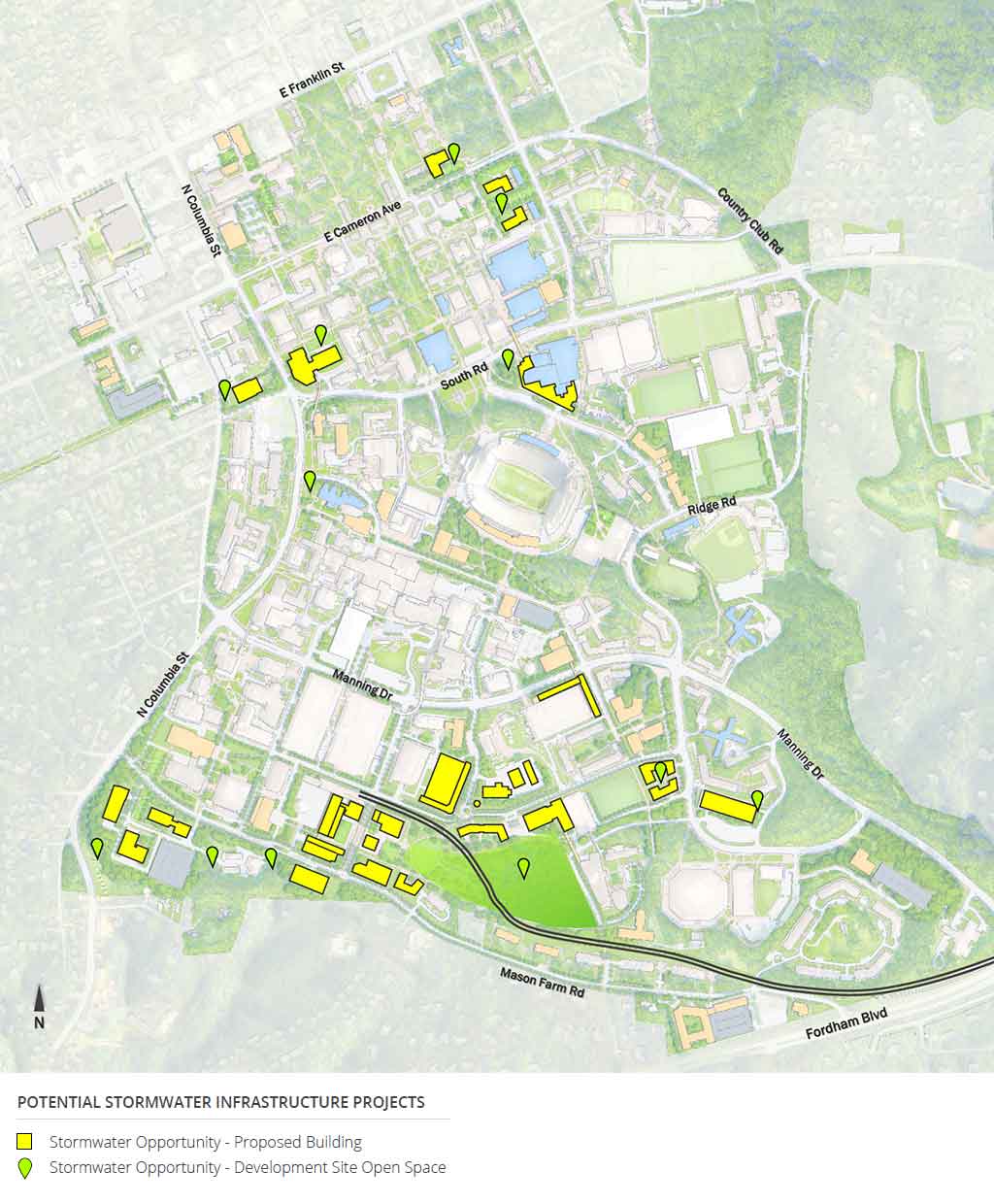
  • Incorporate stormwater management techniques into every project involving campus landscapes. Improve the quality of water that flows from campus through innovative stormwater management.
  • Plan for future utility distribution to new hubs and to outlying parcel development.
  • Design building systems to reduce energy and water use intensity to meet the Three Zeros Environmental Initiative goals.
  • Identify independent priority projects, projects that are conceived expressly for the improvement of the University’s stormwater system’s performance such as the recently completed Battle Grove project, and projects that may involve multiple project sites such as the proposed Campus South Hub.

Potential Stormwater Infrastructure Projects