Connections: Enhance a Comprehensive Network of Pedestrian, Vehicular, Bike and Transit Connections
 The built environment is a powerful tool to connect people and place. The Master Plan enhances Carolina’s unique interconnected campus network of landscapes, streets, and paths that facilitate pedestrian, vehicle, bike, and transit connections within campus and to the broader community. High-quality connections incorporate multiple components including lighting, materials, planting, art, signage, and wayfinding that contribute to overall comfort and safety.
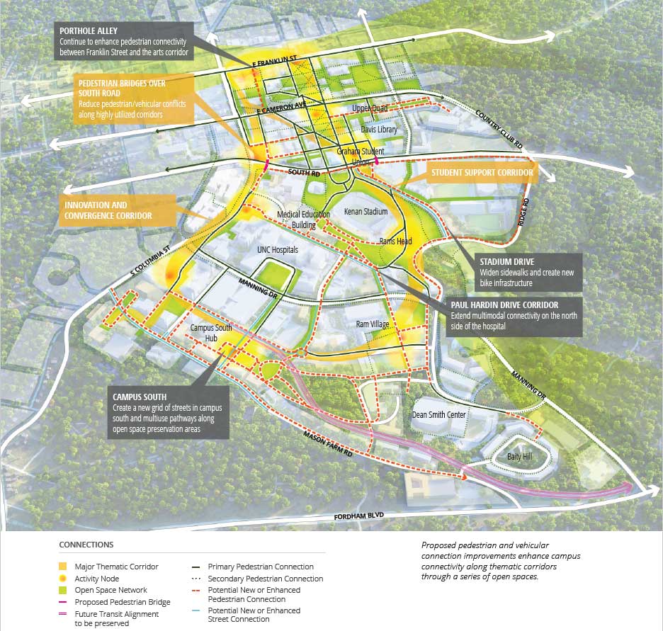
The Master Plan identifies a mix of new connection opportunities that enhance existing connectivity along two thematic campus community corridors. A research corridor on the west edge of campus links the Campus North science complex and the Health Sciences buildings. A student experience corridor to the east encompasses multiple residence halls and student amenities including The Pit, Davis Library, the Student Union, and the Rams Head Center. There is already strong connectivity within these corridors that new projects can enhance in order to provide a quality pedestrian experience for large volumes. Outside of the corridors, the connectivity network must provide access to all key campus resources. Often, topography makes it challenging to create an intuitive connection, but the plan identifies several opportunities to introduce new connections.
What would it look like to have a more connected campus?
- Enhance the campus open space network with each new project.
- Create a rich network with north-south and east-west connections that manage significant changes in topography across campus.
- Create a grid of multimodal streets in Campus South.
- Establish new connections to remote academic resources, such as the expanded Kenan-Flagler Business School.
- Improve pedestrian amenities and prioritize pedestrian access over other modes, where possible.
- Continue to improve accessibility for a diversity of users and create accessible pedestrian connections where physically feasible.
- Emphasize intuitive visual connections.
- Encourage a robust variety of transportation modes—bike, bus, pedestrian, and car—to facilitate connections within campus and to the broader community.
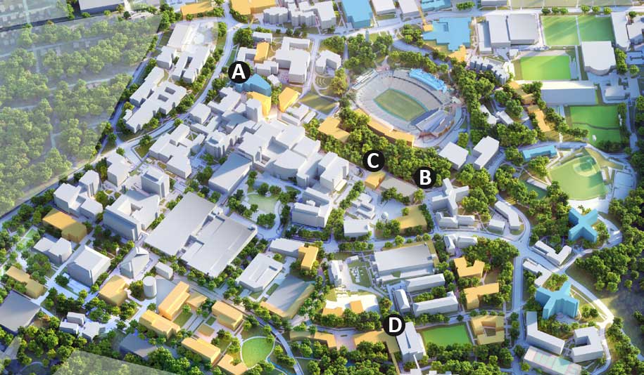
 Medical Education Building
Replacing Berryhill Hall, the Medical Education Building is set to open in 2022 to deliver a modern, cutting-edge curriculum to accommodate a growing physician program. The building further integrates the UNC Health Care System with the School of Medicine and promotes translational education. This project will also improve the pedestrian experience crossing the site east-west from Medical Drive to South Columbia Street.
 S1 Lot Garage
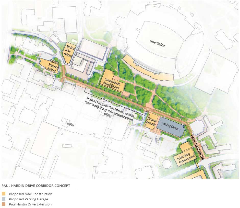
The S1 Lot Garage will expand parking resources on the existing S1 surface parking lot east of the hospital. Design of the proposed garage will be closely coordinated with the adjacent Hospital Central Generator Plant utility infrastructure project and the Paul Hardin Drive Corridor project. This project will build one piece of the extended Paul Hardin Drive, better defining the travel route for both bicycles and pedestrians.
 Hospital Central Generator Plant
The proposed backup generator sited on the S1 surface lot will provide required independent power redundancy to UNC Hospitals and the Surgical Tower project. Located adjacent to a major pedestrian corridor, the design of the facility should promote connectivity goals and prioritize the pedestrian experience. Both the central generator plant and the proposed S1 Lot Garage will contribute to building a part of the proposed Paul Hardin Drive Extension.
 Kenan-Flagler Business School Expansion
An expansion to the Kenan-Flagler Business School is proposed to accommodate growth of the undergraduate program, meet space needs for faculty offices, and provide additional study space and amenities for students and faculty. Beyond meeting space needs, the expansion will improve the quality of facilities to compete with peer institutions and recruit top students and faculty. This facility will connect pedestrians directly to William Blythe Drive, giving the Business School a more public face and enhancing north-south connections for pedestrians, bus transit, and bicyclists.
Feature Projects
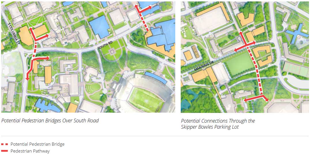
Pedestrian Bridges Over South Road
South Road is a key transportation corridor on the campus but is challenging for all who use it. Pedestrians face heavy vehicle volumes reducing the quality of their experience and overall safety; buses and vehicles are slowed by pedestrians and must remain alert to jaywalkers; pedestrians and cyclists traveling north-south must traverse stairs on the north side of the street. To reduce these conflicts and enhance the experience for all users, the Master Plan identifies locations for two bridges over South Road that were informed by previous studies. Additional studies are required to determine the final locations. These bridges will reinforce key north-south pedestrian corridors, helping to promote activity and exchange across the entire Carolina campus. Both take advantage of the terrain, allowing them to fit into the landscape, the proposed Student Recreation Center expansion, and the expansion of the Science Complex. In addition to enhancing connectivity, the bridges provide a visual cue for drivers marking their entry onto campus. Prior to or concurrently with the building of the bridges, the east-west pedestrian/bicycle corridors should also be improved.
Connections Through the Skipper Bowles Parking Lot
The Skipper Bowles parking lot is an important parking resource in Campus South, but the area surrounding the lot has connectivity limitations that are exacerbated by topography. These make it particularly challenging to access the Kenan-Flagler Business School and its proposed expansion. In the near term, an elevated walkway could facilitate easier access to the Business School and reduce conflicts between pedestrians and vehicles during events at the Smith Center. Adjustments to the Business School parking deck could further enhance vehicular, bike, and pedestrian connections to the Business School. There are important utilities infrastructure and stormwater management concerns that will need to be resolved to redevelop the Skipper Bowles parking lot; however, the site could accommodate important additional capacity for a range of potential uses in the long term. By taking advantage of the site’s topography, new facilities would further strengthen connections in this area.