
Developing the 2007 Plan
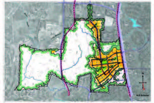
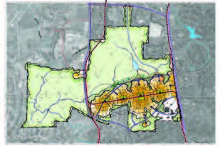
 Based on the site analysis, scenarios were formulated to demonstrate the variety of site development pat-terns. All of the strategies incorporated sustainable, high performance practices, a variety of open space types, hierarchy of streets and service zones, a variety of building heights, parking, and integrated transportation systems. Each of these strategies was in full support of the University’s mission and vision that Carolina North be a vibrant, sustainable, compact, mixed-use academic community. Each scenario also included a variety of parking options and provisions to connect to greenways and bike trails that are pro-posed in the neighboring communities.
Definition of Terms
- Working Landscapes
- Many of the larger natural areas internal to the site and along its edges are characterized as working landscapes. They provide multiple functions beyond the aesthetic and social benefits of open space and landscaping. These functions may include stormwater management and wastewater treatment, low impact recreational opportunities, shallow groundwater recharge, native plant nurseries, native habitat for targeted species, and ecological research and learning opportunities.
- Solar South
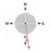 Solar south is different from magnetic south, which can be determined with a compass. It is instead dictated by the geographic location and latitude of a site. The solar south angle takes into consideration the sun’s path from sunrise to sunset and is the alignment that allows the full potential of the sun’s energy and position to be used. At Carolina North, solar south is 8 degrees east of magnetic south.
- High-Performance Buildings
- A high-performance building is defined by the US Department of Energy as a building with energy, economic, and environmental performance that is substantially better than standard practice. Because it is energy efficient, it saves money and natural resources. It is a healthy place for its occupants to live and work and has a relatively low impact on the environment.
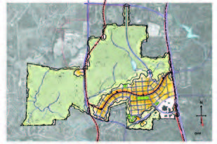
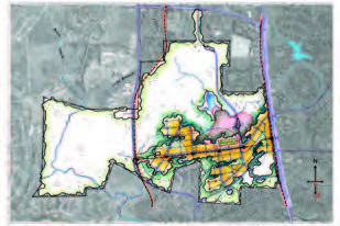
The scenarios that concentrated the development along a north-south spine aimed to keep the development footprint close to the existing Martin Luther King Jr. Boulevard corridor while preserving larger, contiguous forest areas. These designs incorporated a new road stemming south through the site from Homestead Road and a connection through to Estes Drive Extension. They contained an overall gridded pattern of development that still allowed the natural landscape to weave into the developed core. All of these designs showed the majority of development within the previously disturbed land along Martin Luther King Jr. Boulevard near Estes Drive Extension and a pocket of development to the north with a connection to Homestead Road. Pros and cons of the North-South strategy are as follows:
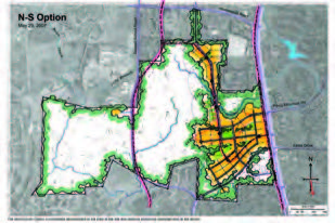
Pros:
- Development concentrated within the Crow Branch Creek watershed
- Integrated restoration strategy for Crow Branch Creek
- Compact development, integrated with large natural areas
- Integrated on-street transit corridor
- Block organization allows a modular implementation strategy
- Development areas are divided by habitat areas – each with a mix of land uses
- More development is situated closer to I-40
- Opportunities to divert the rail corridor through the site and serve large portions of the development if used for fixed guideway transit
Cons:
- Does not optimize already disturbed footprint
- Some development outside of walking distance to transit (more than 1,000 feet)
- Development adjacent to communities to the north
- No roadway connection to the west
- Long-term connections to the rail corridor would be inefficient
- Development spreads further north from connections to Chapel Hill and Carrboro greenways and trails
- Development is more spread out, increasing distances for pedestrian and bike travel
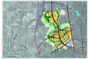
These scenarios focus the development in an east-west pattern, generally aligning with the existing airport runway. This orientation keeps the majority of the development within the previously disturbed land and integrates solar south orientation with the physical plan. The regular pattern of central open spaces acts as an organizing element and brings more working and natural landscape into the core. The integrated transit system stops at regular intervals and the east-west organization allows for nearly all of the development to be located within walking distance of transit. Pros and cons of this strategy are as follows:
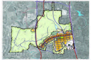
Pros:
- Majority of development is located on already disturbed land
- Retains a large amount of existing forest patch
- Compact development integrated with large natural areas
- Integrates a transit corridor as a central spine
- Evenly distributed access points for transit
- Majority of development within walking distance of transit (1,000 feet)
- Solar south orientation optimized
- Greater balance between pedestrian zones and access/serviceability
- Multiple east-west corridors allow for transit line in separate corridor
- Allows for direct roadway connection to west
- Compact development allows easier pedestrian and bike travel
Cons:
- Some development is located within both the Crow Branch and Bolin Creek watersheds
- Grid layout perceived as visually less interesting than curvilinear patterns in North-South schemes
- Proposed north-south road still ultimately needed even without development to the north